Property Record
1500 E 42Nd St, Chattanooga, TN 37407
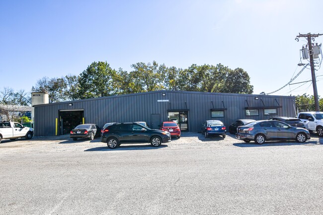

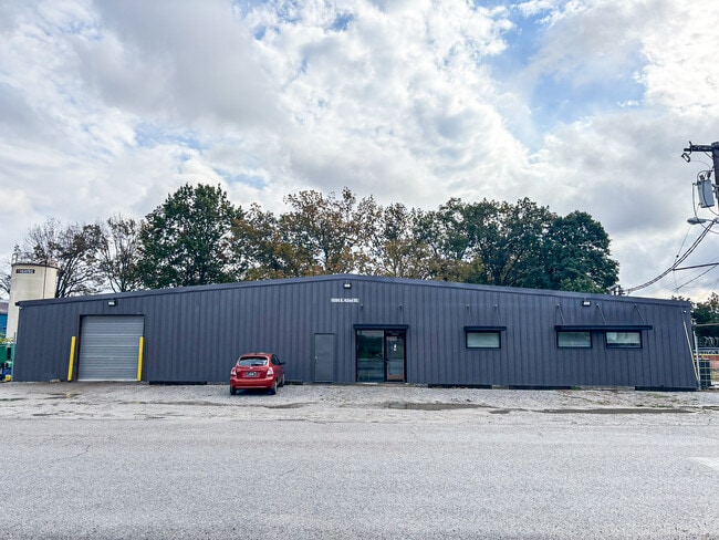
This Property Is For Sale
Current Lease Availabilities
NEARBY LISTINGS FOR SALE OR LEASE
-
-
-
-
-
No Photo
-
-
-
View all Chattanooga listings for sale on LoopNet.com
Property Detail
1500 E 42Nd St
Chattanooga, TN-GA
East End Land Companys Addition #1
168H-K-001
LTS 1-4 BLK 182 EAST END LAND CO ADDN NO 1 PB 2 PG 22
Autorepair
Hamilton
AE
Tennessee
47065C0456G
1-4
2024
0.64 AC
2024
South
002300
Chattanooga
10,000 SF
DEMOGRAPHICS near 1500 E 42Nd St
1 Mile
3 Mile
5 Mile
2024 Total Population
7,974
59,757
137,056
2029 Population
8,508
63,703
146,096
Pop Growth 2024-2029
+ 6.70%
+ 6.60%
+ 6.60%
Average Age
33
38
39
2024 Total Households
2,592
23,725
57,089
HH Growth 2024-2029
+ 6.83%
+ 6.71%
+ 6.91%
Median Household Inc
$32,809
$43,076
$44,670
Avg Household Size
2.80
2.40
2.30
2024 Avg HH Vehicles
2.00
2.00
2.00
Median Home Value
$90,319
$160,707
$179,703
Median Year Built
1948
1960
1965
Nearby Places
Map Layers
Map Styles
 Street
 Aerial
- Restaurants
- Banks
- Shops
- Fitness
- Groceries
PUBLIC TRANSPORTATION
AIRPORT
Lovell Field
DRIVE
WALK
Distance
Lovell Field
18 min
9.1 mi
Freight Ports
Georgia Ports - Savannah
DRIVE
WALK
Distance
Georgia Ports - Savannah
404 min
361.4 mi
Nearby Properties
Address
Land Use
TOTAL SIZE
Lot Size
Zoning
Address
Land Use
TOTAL SIZE
Lot Size
Zoning
296,016 SF
13.36 AC
R3
Address
Land Use
TOTAL SIZE
Lot Size
Zoning
182,932 SF
3.67 AC
M1
Address
Land Use
TOTAL SIZE
Lot Size
Zoning
306,411 SF
6.96 AC
Address
Land Use
TOTAL SIZE
Lot Size
Zoning
279,732 SF
9.39 AC
Address
Land Use
TOTAL SIZE
Lot Size
Zoning
43,470 SF
1.26 AC
R4
Address
Land Use
TOTAL SIZE
Lot Size
Zoning
90,565 SF
18.50 AC
FOR R-2
Address
Land Use
TOTAL SIZE
Lot Size
Zoning
202,748 SF
25.49 AC
M3
Address
Land Use
TOTAL SIZE
Lot Size
Zoning
215,385 SF
14.10 AC
UR
Address
Land Use
TOTAL SIZE
Lot Size
Zoning
458,265 SF
62.80 AC
M1
Address
Land Use
TOTAL SIZE
Lot Size
Zoning
55,289 SF
9.33 AC
C2
Address
Land Use
TOTAL SIZE
Lot Size
Zoning
33.19 AC
M1
Address
Land Use
TOTAL SIZE
Lot Size
Zoning
41,872 SF
7.09 AC
C2
Address
Land Use
TOTAL SIZE
Lot Size
Zoning
172,053 SF
8.07 AC
M1
Address
Land Use
TOTAL SIZE
Lot Size
Zoning
14,585 SF
0.89 AC
C3
Address
Land Use
TOTAL SIZE
Lot Size
Zoning
33,682 SF
0.93 AC
UGC
Address
Land Use
TOTAL SIZE
Lot Size
Zoning
37,044 SF
3.88 AC
UGC
Address
Land Use
TOTAL SIZE
Lot Size
Zoning
60,147 SF
1.99 AC
R4
Address
Land Use
TOTAL SIZE
Lot Size
Zoning
89,163 SF
4.11 AC
M1
Address
Land Use
TOTAL SIZE
Lot Size
Zoning
90,542 SF
2.15 AC
C3
Address
Land Use
TOTAL SIZE
Lot Size
Zoning
86,582 SF
10.26 AC
M1
Address
Land Use
TOTAL SIZE
Lot Size
Zoning
30,438 SF
1.15 AC
UGC
Address
Land Use
TOTAL SIZE
Lot Size
Zoning
25,954 SF
0.77 AC
M1
Address
Land Use
TOTAL SIZE
Lot Size
Zoning
23,530 SF
1.76 AC
R4
Address
Land Use
TOTAL SIZE
Lot Size
Zoning
200,911 SF
13.79 AC
M1
Address
Land Use
TOTAL SIZE
Lot Size
Zoning
86,364 SF
3.16 AC
R3
Address
Land Use
TOTAL SIZE
Lot Size
Zoning
3.49 AC
M1
Address
Land Use
TOTAL SIZE
Lot Size
Zoning
35,364 SF
1.16 AC
M1
Address
Land Use
TOTAL SIZE
Lot Size
Zoning
24,156 SF
7.58 AC
R3
Address
Land Use
TOTAL SIZE
Lot Size
Zoning
113,464 SF
5.60 AC
UR
Address
Land Use
TOTAL SIZE
Lot Size
Zoning
44,382 SF
0.44 AC
R4
The World's #1 Commercial Real Estate Marketplace
Connect with us
© 2026 CoStar Group
The information above has been obtained from sources believed reliable. While we do not doubt its accuracy we have not verified it and make no guarantee, warranty or representation about it. It is your responsibility to independently confirm its accuracy and completeness. Any projections, opinions, assumptions, or estimates used are for example only and do not represent the current or future performance of the property. The value of this transaction to you depends on tax and other factors which should be evaluated by your tax, financial, and legal advisors. You and your advisors should conduct a careful, independent investigation of the property to determine to your satisfaction the suitability of the property for your needs.